
A feature of Trigg Bushland is the parabolic dune, sand dune blow-outs that have been stabilised by a long process of revegetation. Few examples of this type of landform remain within the metropolitan area. The northern rim of the major Trigg parabolic dune borders Karrinyup Road and reaches its eastern extremity just short of the corner with Jeanes Road. The southern rim borders Jeanes Road.
The dunes are composed of white Quindalup sands formed within the last 6,000 years, during a period of rising and falling sea levels. A close examination will reveal shell fragments typical of beach sands.
As these dunes advanced they buried the limestone and yellow sands of the 100,000 years old Spearwood dune system. In some parts of the reserve, north of Karrinyup Road for example, Spearwood sands still occur at the surface.
For an excellent overview of the geology, history, flora and fauna of Trigg Bushland, download ‘The Trigg Dune Reserves’ by Judith Brown (Heritage Australia, Autumn 1986).
For a detailed assessment of the linear belt of the ridge-and-depression dunes, including chaots, south of the cuspate foreland/parabolic dune system, download ‘Assessment of the coastal dunes between Scarborough Beach and Trigg Island‘ by Dr Vic Semeniuk of the V & C Semeniuk Research Group.
For further information on Quindalup and Spearwood soils, refer to Soils of the Swan Coastal Plain (WA Dept of Agriculture & Food website).
MORE ABOUT PARABOLIC DUNES
What has global significance – beyond flora and fauna– making it globally unique? According to Dr Vic Semeniuk, who spoke at the Trigg Bushland/Star Swamp Annual General Meetings on 31st July 2011, the answer to that question is ‘Trigg Bushland.’
Dr Semeniuk explained that none of the other climatically similar areas on the planet – in North or South America, Europe or South Africa – have the same geology as South Western Australia, and therefore the type of landforms that we see exemplified in Trigg Bushland occur nowhere else on the planet.
Dr Semeniuk explained that the rising and falling sea levels, combined with two different types of ocean waves, have created a progression of sand deposition and erosion that results in the unique ‘perched parabolic dunes’ of Trigg Bushland. Not only is the geologic formation unique, but it also exists along the coast in various stages – a ‘living book’ of geology that is there for all to see. Dr Semeniuk explained that with increasing population and land use it is becoming more difficult to see the geologic steps that lead to the parabolic dune.
Between the linear trough of the Darling Scarp through to the sea bed, the sea level sank and rose 12 times, creating ridges of sand that calcified and became rock, and with variation in sea levels these remnant shorelines become offshore islands. Swell waves from the southern ocean create gaps between islands, driving sand northwards at an angle, leaving sawtoothed deposits on the mainland beach. Smaller waves created by sea breezes coming from the west form tooth-shaped cuspate forelands on the mainland as they further erode the islands.
So north moving sand is trapped behind islands, on the mainland coast. And once on the coast – the wind takes over. As Dr Semeniuk says, ‘Wind sucks, it doesn’t blow!’ Negative pressure from warm, rising air in the interior sucks in cool air at the coast, creating wind and blowing the sand towards the east.
The cuspate forelands are eventually completely blown from the shoreline into dunes on the mainland. Over time, the loose sand forms parabolic dunes, which collapse and reform to create the ‘nested perched’ dunes, one inside the other, that can clearly be seen in Trigg Bushland today.
Dr Semeniuk explanined that this progression is ongoing, and all steps of the process can be seen in the current geology of our coastline between Jurien Bay and Bunbury. It forms part of what he calls our ‘geoheritage’ – a living library of natural history illustrating a unique process which has only recent been fully understood. Dr Semeniuk argued strongly that this heritage, including Trigg Bushland, needs to be fully preserved in all its development stages as part of the history of the formation of the earth.
-N McLaren
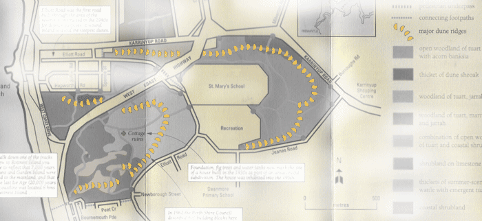
Nested parabolic dunes shown in yellow.
MORE ABOUT SHORE PARALLEL DUNES, SEA CLIFFS AND CHAOT DUNES
The coastal dunes between Scarborough Beach and Trigg Island are essentially a single set of coastal dunes comprised of shore-parallel sand ridges and depressions. They front a terrain of former limestone cliffs. Today, as a result of storms and wind mobilisation to landward of the fore-dunes, the entire belt of coastal dunes between Scarborough Beach and Trigg Island is cliffed at its seaward edge at its contact with the storm level of the beach and, as such, there is no fore-dune – the first dune is the first sand ridge some 5 m high.
While the largest scale of landforms consist of shore-parallel sand ridges and depressions, each some 15-25 m wide, with 2-3 ridges comprising the coastal set, at the smaller scale, the ridges themselves and the depressions are comprised of ‘chaots’. Geomorphically, and in terms of coastal geoheritage, the significance of the dune belt of sand-ridge-and-linear-depressions in the Scarborough Beach and Trigg Island area is that in the central coastal and southern coastal plain area they are not that common. Further north, the wind direction changes direction and coastal dunes also correspondingly change form and are incomparable. The only other location where there is a linearly extensive narrow belt of shore-parallel beach ridges is at North Cottesloe.
From a geoheritage perspective, the sand ridge belt of the Scarborough Beach and Trigg Island area is evaluated as of State-wide significance because of the occurrence of a linear belt of the ridge-and-depression system outside a system of a cuspate foreland, and the occurrence of chaots as the smaller-scale landforms comprising the ridges and the depressions.
More information: download ‘Assessment of the coastal dunes between Scarborough Beach and Trigg Island‘ by Dr Vic Semeniuk of the V & C Semeniuk Research Group.
Recent Comments