PROPOSED COASTAL DUNE BOARDWALK – SOUTH TRIGG BEACH RESERVE
Submission from the Stop the Boardwalk Action Group to the City of Stirling
The Stop the Boardwalk Action Group was established in 2011 when residents and conservation groups became aware that a boardwalk proposal similar to that rejected by the public and the Council in 2005, was back on the Council’s agenda. Our group has members and support from: the Friends of Trigg Bushland Inc, Friends of Star Swamp Inc, Urban Bushland Council WA Inc, Stirling Natural Environment Coastcare Inc, local residents and concerned members of the public.
Our objectives are to ensure that the integrity of the South Trigg Beach Class A Reserve Bush Forever Site 308 is preserved for this and future generations. Reference throughout this submission to the South Trigg Beach Class A Reserve No 46248 includes the Esplanade road reserve that is in the process of being amalgamated into the Class A Reserve.i
We are opposed to the City of Stirling’s proposal to construct a boardwalk and concrete path through the coastal reserve and wish to register our opposition to all of the three boardwalk options A,B and C. Any of the options proposed would cause irreversible and on-going damage and disturbance to the environment of this regionally significant and locally important coastal reserve.
We are primarily opposed to the three proposed boardwalk options for environmental reasons, however, we also have concerns about the aesthetics, public safety, public amenity, cost and lack of proper process involved. We will elaborate on the grounds for our objections in the body of this submission.
Firstly, we are pleased to advise that we have received support from numerous community groups and expert advice and support from professionals in various fields; some of whom have made individual submissions opposing the construction of a boardwalk on environmental and other grounds.
The community groups that have offered support are:
Expert advice and support has been received from:
Class A Reserve and Bush Forever status
The City recognised the environmental significance of the remnant vegetated dune system between North Scarborough Beach and South Trigg Beach in 1998 when it applied for its reclassification from Class C to Class A Reserve.
In the same year, the State Government included the Trigg Bushland and Adjacent Coastal Reserve in Perth’s Bushplan which subsequently became Bush Forever Area 308. Bush Forever designation recognises the coastal reserve’s regional significance and its conservation value representing landform, soil, vegetation, flora and fauna. The reserve’s classification as Class A Reserve (the Esplanade Road Reserve is pending amalgamation into Class A Reserve No 46428) and Bush Forever, gives it the highest available conservation protection. It is the only coastal reserve in the City of Stirling to have this level of protection.
The Class A Reserve and Bush Forever status requires through State Government legislation, that any proposed development must show clear environmental benefits. The boardwalk proposals do not have any clear environmental benefits and on the contrary, all three options would result in degradation of the reserve. Evidence of the potential for degradation is provided in the body of this submission.
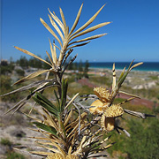
The coastal reserve is regionally significant as an example of an intact Quindalup dune foreshore in near pristine condition. We have attached a map showing the Bush Forever boundaries (marked with diagonal stripe) with the results of a flora survey showing “Pristine” and “Good” areas within the reserve. (Attach 1)
Effects of disturbance - weeds
In her recent paper “Native and Weed Mapping, Management and Restoration of the City of Stirling Coastal Zone” Dr Judy Fisher observes that the South Trigg Beach Reserve narrow dunal system is unique in that it is the only coastal reserve in the City of Stirling where there remains a complete complex of foredunes, swale and secondary dunal systems connected to inland and significant native remnant vegetation for approximately 2 kms inland in the Trigg Bushland Reserve.ii
Dr Fisher has described the landscape in the coastal dune reserve as “…complex topographically, due to the fragile biogeography of the region.” She describes different vegetation communities in swales and valleys dependent on the direction they face. With south facing dunes having different plant communities to those facing north, producing their own micro-climates which, if disturbed would place the “good areas” at great risk of degradation and weed invasion from other areas.iii She describes any disturbance, such as digging of the soil, as stimulating weed seeds within the soil, which because of their highly competitive nature will grow rapidly. It is logical to project that the construction of a boardwalk, viewing platforms and a concrete ground level path within a 4 metre corridor would cause disturbance to the sand dunes and as a result would require an expensive on going weed management program.
Boardwalks
Unfounded claims have been made by the City that the proposed boardwalk would protect the environment. The three options proposed are not “boardwalks” as popularly understood. Furthermore, although it is true that some boardwalks are appropriate in particular environments where for example, there is heavy foot traffic and the landscape has greater topographic variation and vegetation height greatly increasing the ability of the landscape to absorb the visual impact of fixed structures. Kings Park is an example of this. The dune system at South Trigg Beach Reserve is vegetated with low coastal heath where a raised aluminium boardwalk and a fenced concrete path within a 4 metre corridor would be an unsightly intrusion into a natural area that is currently not experiencing unregulated or heavy foot traffic.
Some of the common problems experienced with boardwalks in natural areas are: cost – they cost a substantial amount of public money to construct and to maintain; they are often over-engineered and are an eyesore; they are commonly destructive of the vegetation they are supposed to protect during construction; they are often not well used or alternatively, attract too much use requiring further access structures in a previously pristine area; boardwalks often fall into disrepair because of the high maintenance cost and their location in areas inaccessible to vehicles; they have high maintenance costs which increase annually.
Dr Fisher’s conclusion is worthy of direct quotation: “In order to adequately conserve these areas (South Trigg Beach Bush Forever dunal areas) particularly at a time of reduced rainfall, when native plants are becoming heavily stressed, it is recommended that this whole area become a high priority for immediate protection, management and investment, to ensure ongoing connectivity across this landscape, and reduce long term management costs.”
Coastal Foreshore Action Plan and Rising Sea Levels
Another worthy and relevant report is the “Coastal Foreshore Action Plan Trigg Island to Peasholm Street” prepared for the City of Stirling by Dr Julian Clifton, School of Earth and Environment UWA June 2010. This report refers to plans by the City to focus recreational activities on Scarborough and Trigg and the need for careful management in light of the conservation significance of the adjacent foreshore. The report states that there is an urgent need to quantify the rate and impact of projected sea level rise which could have “highly detrimental consequences” for the habitats of the foreshore. Dr Clifton observes the present situation as lacking detail particularly with regard to local trends in sediment movement and beach morphology.
There is no evidence in the “Summary of Key Issues Trigg to SEAS Boardwalk” that any attempt has been made to quantify the impact of projected sea level rise on the proposal to construct an 800 metre long elevated boardwalk and at-grade concrete path through the dune foreshore at South Trigg Beach. The Department of Planning’s 2003 State Coastal Planning Policy recommends setback distances for development proposals in order to provide protection from physical coastal processes over the next 100 years. Setback requirements for open beaches and dunes have been calculated at 62m, although Dr Clifton suggests that this calculation deserves revision in light of more recent data.
Dr Clifton advises of the need for systematic monitoring of the natural coastal environment from both a physical and ecological standpoint and that such monitoring is a fundamental pre-requisite if future uses of the foreshore are to be sustainable, both economically and environmentally. The absence of research by the City’s Engineering Design department into setback requirements is a significant omission when considering the construction of a static structure such as an elevated aluminium boardwalk parallel to the shoreline on a narrow strip of vegetated primary and mobile dune.
Summary:
Views
The unobstructed view across the dune reserve to the ocean from the shared path and the road along West Coast Highway for the length of the dune reserve (approximately 800 metres) is currently enjoyed by pedestrians, cyclists and motorists.
The visual impact of an elevated aluminium boardwalk and seven aluminium viewing platforms (with or without roofs) along the length of this relatively pristine dune reserve would be an ugly intrusion and would spoil the uninterrupted views to the ocean over the vegetated dunes and sandy beach that everyone currently enjoys from the road and the path. This view, currently unspoiled by any artificial structures, would be destroyed with the construction of any of the three boardwalk options being proposed.
An aluminium boardwalk and viewing platforms would dominate the low dunes and shrubs like a mining conveyor belt and would destroy the essential bush character of the Trigg Beach. Despite claims to the contrary, aluminium even when anodised, will reflect the sun, be shiny, noisy and visible from the road, the footpath and nearby houses.
Existing lookout
In addition to the stunning views available from the shared path, there is an existing lookout that has been neglected by the City of Stirling for years, is weed infested and has no seating. This lookout could be upgraded and made accessible for wheelchairs with little effort or expense and would provide a resting place for pedestrians and beach users accessing the beach along the existing path.
The shared path
The City has claimed that pedestrians are unsafe on the current shared path along West Coast Highway. No evidence has been provided that the shared path is dangerous for pedestrians. No accident statistics have been provided, and we are unaware of any collisions on this path. Observations made by members of our group are that people are generally considerate in making way for people pushing prams and allowing cyclists to pass. It appears that claims being made that this path is underused and dangerous to pedestrians is the opinion of some individuals who are supporting the construction of a boardwalk through the coastal reserve, but is not a view that is generally held or expressed.
If this shared path is as dangerous and is avoided in the way that has been claimed, the City should have by now upgraded and widened the path to the 4 metres that is standard on other coastal shared paths in the City of Stirling. Not to have done so, if there is evidence that it is dangerous, is negligent.
There are already two pedestrian links, one on the dual use footpath along West Coast Highway and one along the flat beach between the dunes and the ocean. There is no evidence of demand for a third link through this narrow coastal dune system.
Exclusivity
There is no guarantee pedestrians will not continue to use the shared path even if a boardwalk alternative is available to, for instance, access the east side of West Coast Highway. The shared path will continue to be the most direct route for many people walking from Scarborough to Trigg. It is not possible to exclude pedestrians from this path, nor is it fair to give speeding cyclists exclusive access.
Cyclists have advised us that 800 metres of an exclusive use path is of negligible interest to them when they are cycling many kilometres on various routes along the coast. They have also assured us that they would not be confident that pedestrians would not continue to use the path.
Furthermore, there is no guarantee cyclists will not use the boardwalk. In fact, the City has acknowledged that it will not be possible to keep cyclists off the boardwalk. The same would apply to skateboarders, roller bladers, even motor bikes given that the boardwalk would be linking car parks.
Shared paths work well in other parts of the City of Stirling, why is it that this particular path is singled out for different treatment? Cyclists can ride on the road if they wish to travel above the safe speed limit on the path, as they do on other roads in the City. Cyclists use other parts of the West Coast Highway, it is not true to say that this stretch of road is any more dangerous than other sections of this road. The section of the shared path to be made exclusive to cyclists is only 800 metres long, why is it different?
Pedestrians
Safety for pedestrians can be improved by other methods. The shared path can be widened with minimal incursion into the reserve, noting that there is already an unused verge between the path and the fence for much of the length of the path. Another way to improve the path would be to extend the low fence that runs alongside the underpass for the length of the dual use footpath. The 60 kph speed limit could be extended further north along the highway with minimal disruption to traffic.
The City has been negligent in not upgrading and improving this path since the last boardwalk proposal in 2005, it should just get on with it.
Lighting
The City has not provided any information or costing for lighting along the 800 metre boardwalk. Few people would be prepared to walk along the boardwalk at night with or without lighting, with no exit available or access for emergency vehicles. With increased access the opportunity for anti-social behaviour including drinking of alcohol on (and under) the boardwalk and viewing platforms would be high, especially at night. There are already reports of some problems in this area with illegal camping and parties.
Other safety issues
The potential for conflict between users of the boardwalk is high, if as the City claims, the path will be used by families with prams, children on bikes and people in wheelchairs. It is also likely that skateboarders would find speeding on such a structure to be an attractive activity. There is nothing to prevent motor bikes illegally using the boardwalk as it would link two car parks.
The risk of fire would be greatly increased by anti social behaviour on the boardwalk, for example cigarette butts would quickly ignite dry dune vegetation, and other activities attractive to arsonists could easily be undertaken with access to what are currently relatively inaccessible areas of vegetated dunes.
Safety for people using wheelchairs would be compromised by a path 800 metres in length without a safe exit point and inaccessible to emergency vehicles. Sections of the path do not fully meet wheelchair standards for width and the possibility of conflict between users on these narrow sections (1.2 – 1.8 m) of path is high. This narrow width has been described in the Summary of Key Issues as adding “to the experience and (to) provide excitement”.
Significant delays could result should events occur requiring emergency vehicles which would be forced to drive into the area for ambulance, fire or police purposes, all of which would become more likely with the introduction of people and dogs into currently inaccessible areas.
Litter
The South Trigg Beach Reserve is currently relatively free of litter, there is no doubt a boardwalk would introduce litter such as food and drink containers into the coastal dune reserve. Access for the collection of rubbish bins would be another problem for the City to overcome involving more expenditure and the possibility of damage to the environment.
Visual amenity
The coastal reserve provides local people and visitors with a refreshing, visually pleasant, natural break between the buildings at Scarborough and Trigg, a place to rest the eye. It is a highly valuable natural area that provides a snapshot for posterity and for future generations to appreciate how our coastline used to look. It is a natural asset and is also a valuable tourist attraction.
Access
Claims have been made by City representatives that people are unable to enjoy the pristine dune system if it is inaccessible. This demonstrates a lack of understanding that pristine bushland preserves plants and animals that would not be able to survive unless their ecosystem is left intact. Bushland is not just for our personal enjoyment. Furthermore, it is not true to claim the reserve is inaccessible, there are three paths that can be used to access the beach from the shared path along West Coast Highway and from the east of the road via the underpass.
This pristine dune system is a living laboratory for the study of our unique coastal flora and fauna, by students and nature lovers. All those who appreciate the beauty of the Perth coastline will fight to preserve this untouched, undeveloped coastal dune reserve, that is essential to the preservation of the biodiversity that makes the Swan Coastal Plain so unique,
The three boardwalk options have been costed at $1.05m, $3.81m and $1.87m with no provision for lighting, on going maintenance, rehabilitation of the dunes or extra expenses such as rubbish removal, emergency services and policing of anti-social behaviour.
The City has admitted that the boardwalk is unfunded however, the Ward Councillors have claimed that private funding will be sought to build the boardwalk. Would this result in advertising on the boardwalk and/or viewing platforms?
Professor Paul Hardisty has prepared a “Preliminary Analysis of Broader Life Cycle Environmental Social and Economic Costs and Benefits” paper to make a notional comparison point for what likely additional benefits would have to be to justify construction of a boardwalk. A copy of his paper is attached.iv (Attach 3)
Please note that the City’s preferred Option C has been found by Professor Hardisty to be the most expensive option, when the true economic value of an “unspoiled” beach environment is taken into account. This is a method of evaluating projects that progressive local governments are taking into account as part of their normal review processes.
Ratepayers and taxpayers have every right to ask why they should pay for an expensive, unnecessary boardwalk, and continue to pay for its maintenance and upkeep into the future, when there are so many areas in the City of Stirling that would benefit from expenditure on, for instance, upgrading footpaths to make them safer and accessible for people in wheelchairs; providing accessible toilets for wheelchair users in public parks; maintenance and weeding programs for the City’s natural areas such as the Trigg Bushland Reserve.
Beyond the boundaries
Why has the City of Stirling taken the unprecedented step of going beyond its boundaries for a “Community Consultation”? Is this because the City knows that local residents oppose this expensive and environmentally damaging boardwalk proposal?
In 2005 the public overwhelmingly rejected a proposal to build a boardwalk through the South Trigg Beach Reserve along a similar route to the current proposal. In response, the Council voted against proceeding with the boardwalk. It is completely inappropriate for the City to take this new proposal outside the City boundaries in the hope of gaining support for a boardwalk that has been previously rejected by residents within the City.
Misrepresentation
The City of Stirling has consistently misrepresented its proposal as a “boardwalk” creating the impression that it would be low impact visually and environmentally. The proposal is not as most people understand a “boardwalk”. The Council’s preferred option C is the only one that has been advertised in the local paper and in Stirling Scene Autumn Edition. In these pictures and articles the boardwalk is described as a “Pedestrian Walk” and gives the impression that it is a ground level path that meanders through the dunes. It does not give any information about the height or width of the path, the percentage that would be elevated (approximately 50%) and what height or construction material would be used on the seven “Viewpoints”.
The boardwalk in fact would be a shiny metal skybridge based on the Yanchep skybridge and half of it would be at ground level made of concrete and within a 4 metre wide cleared corridor. Where is this information presented to the public in a clear and detailed manner? City officers have publicly stated that the boardwalk is a “concept only” and that it is “unfinished” and “unfunded”. Does this mean when and if a design is decided upon, it would be once again presented to the public for comment?
Lack of public information
The City usually seeks comments by advertising signs on site, letterboxing information and other forms of publicity when proposing significant developments that would affect the amenity of the surrounding residences. Not in this case, why not? Is the City deliberately giving this proposal a low profile so as not to attract opposition?
There is no excuse for keeping vital information from the public when it involves a substantial and expensive proposal on Crown Land, and when their opinion is being sought.
Conclusion
The Stop the Boardwalk Action Group is extremely concerned that the City of Stirling who are custodians of this regionally and locally significant coastal reserve, with a duty to care and protect the environment, landscape, flora and fauna for current and future generations, persists in proposing developments that would cause irreversible environmental damage.
The three boardwalk options are all contrary to the best interests of this unique and precious dune system and should immediately be withdrawn and efforts and money instead be directed at protection of the South Trigg Beach Reserve.
The City’s first priority and its responsibility is to protect the reserve from disturbance and take advice from its own officers who in March 2011 reported to Council that: “Construction of the boardwalk is likely to result in significant impacts to nature dune systems from which recovery and restoration would be difficult under the constraints of the coastal environment.” We couldn’t have said it better ourselves!
This submission has been jointly prepared and written by Nina McLaren and Robyn Murphy, representatives of the Stop the Boardwalk Action Group. Information on the group and its campaign can be found on our web page www.triggbushland.org.au/stoptheboardwalk.htm.
i Letter from City of Stirling 16 May 2012
ii Dr Judy Fisher Extract from “Native and Weed Mapping, Management and Restoration of the City of Stirling Coastal Zone (2011-2013)” Fisher Research Pty Ltd
iii Dr Judy Fisher ibid
iv Professor Paul E Hardisty “Preliminary Analysis of Broader Life Cycle Environmental Social and Economic Costs and Benefits” 18 April 2013
Attachments 1. – Map showing boundaries of Bush Forever 308; 2. Photo of construction of Floreat Beach Boardwalk; 3. Professor Hardisty’s paper (see reference above).
* * * * *
Download the submission and attachments:
Download Submission; Download Attachment 1; Download Attachment 2; Download Attachment 3
Return to Main Page
For more information contact the Stop the Boardwalk Action Group at stoptheboardwalk@gmail.com